
Synergy of the French MDSI (Measurements of Deformations by Spatial Imaging) community of ForM@Ter for the interpretation and understanding of geophysical phenomena from space data: respond quickly during a natural disaster.
The Scientific and Technical Intervention and Expertise Cell (CIEST) was created in France in 2005 through an agreement between six national organizations (BRGM, CEA, INSU, IPGP, IRD, UCBL). The objective was to extend the use of space resources, and in particular the SPOT images acquired under the International Charter “Space and Major Disasters”, for the understanding and study of geological hazards.
In 2019, about thirty French scientists have expressed interest in reactivating this initiative on the Pleiades stereo database. We call this revival CIEST²: CIEST new generation, which is now placed in the framework of the national data and services cluster dedicated to the Solid Earth ForM@Ter.
This synergy should stimulate the sharing and dissemination of results for multidisciplinary and inter-institutional geophysical interpretation.
Principles
The activation of the CIEST² can be requested following an activation of the Chart or if an interest for a geophysical event is expressed by a scientist from a French laboratory and member of the CIEST².
CNES will then trigger Pleiades programming for DMS generation or multitemporal monitoring. The community can use specific or common tools via the ForM@Ter optical services or the PEPS and GEP platforms, for Sentinel 1-2 processing in addition to Pleiades.
Essential point: this synergy must stimulate the sharing and dissemination of results for multidisciplinary and inter-institutional geophysical interpretation.
Organization
A steering committee is created with some scientists representing the different themes and several French laboratories: BRGM, EOST, IPGP, ISTerre, LEGOS, OPGC, CESBIO.
The generic address of the committee is :

A list of email addresses of user scientists is established for exchanges:

The inscription to this list is done on request to the steering committee.
CNES is the contact point with ADS for Pleiades programming. The images are made available to the French scientific community after signing the Pleiades DPS (Delegation of Public Service) license. Access to the data for non-French scientists is subject to the signature of an additional agreement by the organization concerned.
Pleiades (and Sentinel) processing results are shared within the CIEST² community and presented via this WEB page. Depending on the case, the resulting geophysical interpretations may remain confidential until publication.
Stages of activation
CIEST² can be activated in case of landslides, earthquakes, volcanic eruptions or glacier collapses.
NB: when the International Chart “Space and Major Disasters” has been activated, CNES warns the CIEST² community by indicating the area that will be imaged by the Chart (most of the time without stereo mode).
– The activation request is to be sent to the CIEST² steering committee.
– The steering committee decides on the activation and coordinates the needs in images (archives or to be acquired), the zones of programming (stereo or not).
– The request to program Pleiades in “fast” mode is managed by CNES in high priority emergency mode at Airbus DS.
CIEST²: examples of results obtained from seismotectonic hazards
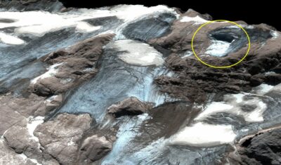
Estimation of Marmolada glacier collapse volume using Pléiades imagery
The deadly Marmolada glacier collapse happened on 3 July 2022. On 6 July 2022, Pléiades 1B (CNES, Airbus DS) acquired a clear-sky stereo pair of the area. From these images we could estimate a […]
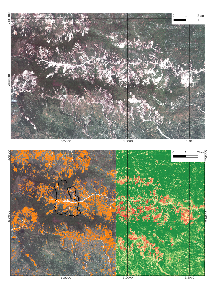
Analysis performed with the ALADIM GEP service to construct automated landslide inventories using Pléiades very-high resolution images
On 14-08-2021, a Mw 7.2 earthquake hit Haïti. This event was followed by a few days of heavy rains triggered by tropical depression Grace. The combination of these extreme phenomena triggered a large number of landslides in the hilly region of Haïti, especially in the region of the Pic Macaya National Park.